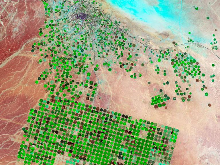
Irrigated Crop Circles, Saudi ArabiaCrop circles dot the Wadi As-Sirhan Basin in Saudi Arabia in 2012. A series of satellite images taken by NASA from 1987 to the present in this same location reveal the emergence of an agricultural empire that has come to dominate the landscape. Just 15 years ago there were no signs of farming in the basin.Saudi farmers, like those on the American High Plains, are fueling the production of grains in the desert by mining underground reserves of water. Some of that water dates back 20,000 years, to the last ice age, when more temperate conditions filled aquifers.On the ground, these circles are as wide as the aquifers are deep—about a kilometer, or .62 mile—and are formed by the use of center-pivot irrigation sprinklers that draw on the groundwater. Many of the crops are grown to feed a bustling cattle industry.(Related: “Saudi Arabia's Great Thirst.”)
IMAGE COURTESY ROBERT SIMMON AND JESSE ALLEN, USGS/NASA
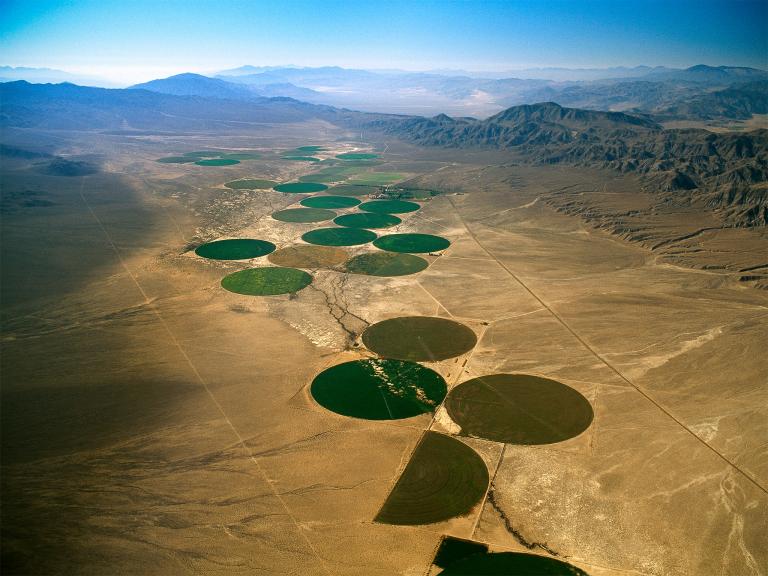
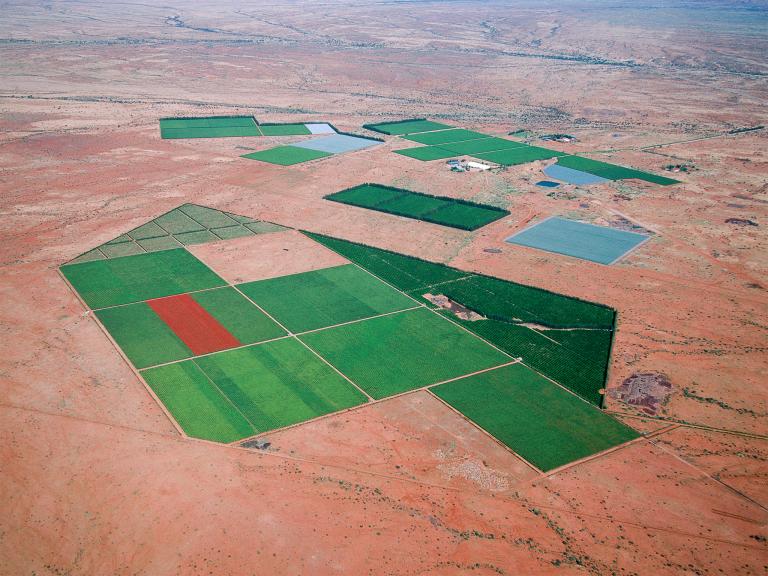
American Crop Circles, NevadaA center-pivot irrigation system creates life in the Nevada desert.Nevada's water comes from a variety of sources, including groundwater and diversions piped in from the Colorado River.The water used worldwide for growing crops for food, textiles, and fuel accounts for nearly two-thirds of all freshwater use. That percentage can creep up to 90 in particularly arid regions, where the sun's heat evaporates a significant portion of irrigation water before it even hits the ground.PHOTOGRAPH BY JIM WARK, AGSTOCK IMAGES/CORBIS
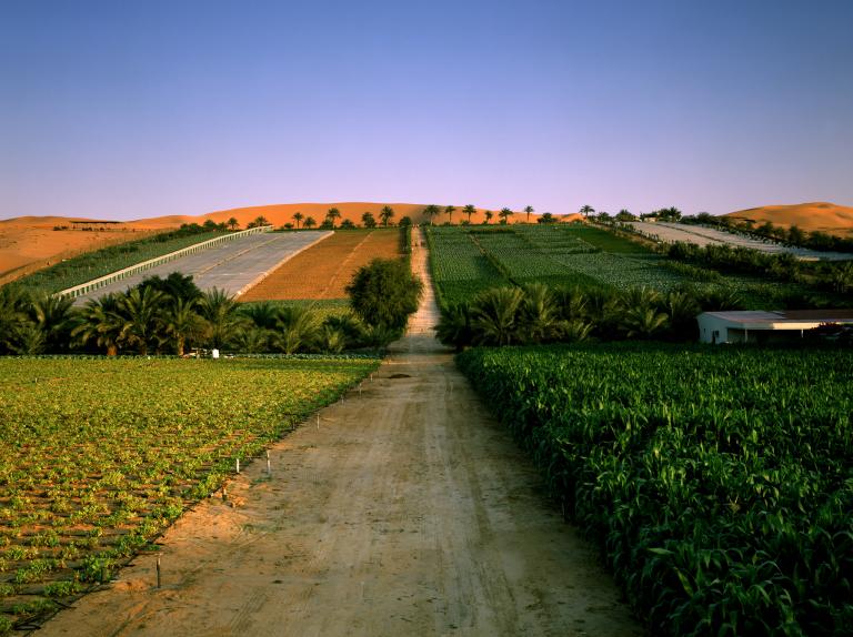
Oasis Crops, United Arab EmiratesA true oasis in the desert, the Liwa Oasis supports rows of lush green crops that border desert sands in the United Arab Emirates.(See more pictures of desert landscapes.)The oasis, one of the biggest on the Arabian Peninsula, hosts a series of Bedouin villages and farms that have relied on groundwater since the 16th century. Historically a date-producing area, the oasis now grows cereal grains, vegetables, and other fruit trees as well. It also features luxury hotels and spas for tourists from neighboring Persian Gulf cities.(Related: “Our Oversized Groundwater Footprint.“)
PHOTOGRAPH BY RICHARD ALLENBY-PRATT, ARABIANEYE/CORBIS
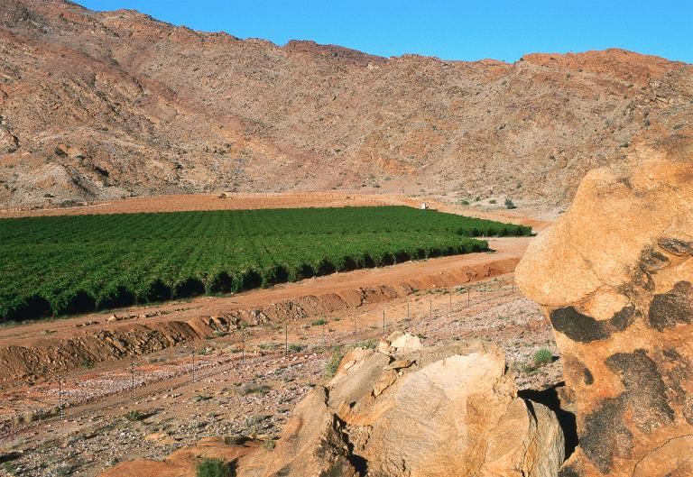
Desert Vineyards, South AfricaVineyards pop out of the desert in South Africa's Northern Cape Province. This popular wine-making region is nearAugrabies Falls National Park, where the Orange River tumbles down steep rock cliffs.Named for the desert silt it collects along its path, the river starts in the Drakensberg Mountains and ends up serving as the border between South Africa and Namibia.Carefully cultivated grapes can thrive in semiarid conditions with little water. It takes 63 gallons (240 liters) of water, mostly for irrigation, to make one cup of wine, compared to 132 gallons (500 liters) to grow one pound (.5 kilograms) of wheat.(Explore the hidden water footprints of dozens of food crops in National Geographic's online embedded water interactive.)
PHOTOGRAPH BY RICHARD DU TOIT, GALLO IMAGES/GETTY IMAGES
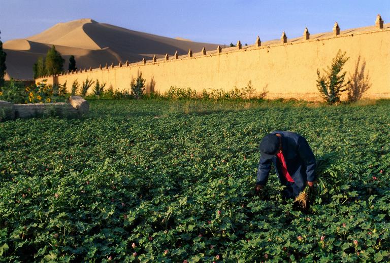
Irrigated Cotton, ChinaA farmworker tends to cotton crops near the city of Dunhuang in China's Gansu Province.Once a stop on the Silk Road, Dunhuang, previously Shāzhōu, was known as the “City of Sand”—and an oasis in the vast Gobi. Farming has been a tradition there for thousands of years. The once delicate use of water for irrigation has become more aggressive over time, with a growing population requiring the damming of surface water from the nearby Dang River and the extraction of more groundwater.”I would call it an ecological crisis,” Zhang Mingquan, a professor at Lanzhou University who specializes in the region's hydrology, told the New York Times in 2005. “The problem is the human impact. People are overusing the amount of water that the area can sustain.”(Learn more about the global impact of growing crops in major river basins with National Geographic's Global Water Footprint interactive.)
PHOTOGRAPH BY KEREN SU, GETTY IMAGES
Arid Orchards, Kalahari DesertVerdant grape vines are nestled among desert cliffs in South Africa's Northern Cape Province. Vineyards and orchards in this corner of the Kalahari Desert, near the fertile banks of the Orange, or Senqu, River, are a popular tourist destination.The Kalahari is an incredibly diverse region, with barren sands, large tracts of grazing land, and one of the world’s most pristine wetland areas. This semiarid desert extends north from South Africa into Namibia and Botswana, where it runs into the Okavango River and its unique inland delta—a critical sanctuary for wildlife.